
After weeks of non-stop rain, communities across Minnesota are battling swollen rivers, washed-out roads and trails, and a home toppling into the Blue Earth River near the 100-year old Rapidan Dam. In the east metro area, “No-Wake” restrictions are in effect for the St. Croix River and watershed districts are also urging boaters to go slow on local lakes to avoid damaging shorelines with large wakes and waves.
In St. Paul, the Mississippi River has risen four feet in less than a week and Fort Snelling State Park is currently closed until the water recedes. In northeastern Minnesota, there are more than 40 closed roads across St. Louis County, as well as washouts and damage on the Gitchi Gami and North Shore State Trails. Lake Vermilion-Soudan Underground Mine State Park has canceled tours due to flooding and numerous BWCA campers were stranded last week while attempting to return home from their trips.
Southern Minnesota has been hard-hit as well. This week, the Minnesota National Guard was activated to assist the community of Waterville in Le Sueur County, which received 14 to 18 inches of rain. Further west, the Blue Earth River has carved a new channel around the failing Rapidan Dam, which is located southwest of Mankato. Traffic is currently closed on Hwy 169 between Mankato and Le Sueur. In addition, cave tours at Forestville/Mystery Cave State Park, as well as bison and prairie tours at Blue Mounds State Park, are canceled due to flooding.
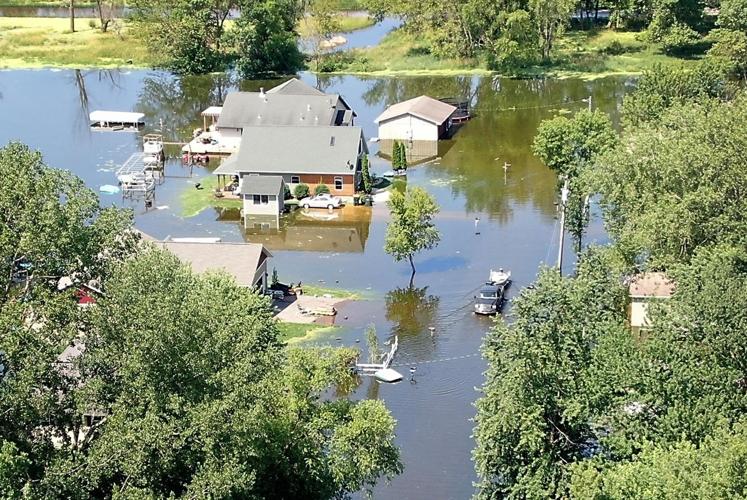
Thanks to the efforts of local watershed districts, most neighborhoods in the Twin Cities metro area have managed to stay dry, even as other parts of the state go underwater. In Washington County, for example, the Brown’s Creek, Carnelian-Marine-St. Croix, South Washington, and Valley Branch Watershed Districts all manage flood-relief projects that carry water away from land-locked areas when lakes and wetlands become overly saturated. Even so, watershed districts are asking boaters to take it slow until the water recedes to avoid damaging shoreline property with wakes and waves. In addition, the St. Croix River currently has a “slow-no wake” restriction in effect for the entire lower river, from Taylors Falls to Prescott.
To understand why wakes cause so many problems, consider how difficult it is to carry an overly full cup of coffee without spilling. The same phenomenon happens in lakes and rivers during high water conditions. Fast moving boats, and especially wake boats, create waves that ripple out across the water until they hit the shore. Even during normal water conditions, large waves can cause shoreline erosion. When water levels are high, however, the waves are even more likely to damage docks and boats, as well as chisel-away at upland trees and vegetation.
Research from the University of Minnesota St. Anthony Falls Laboratory demonstrates that wakesurf boats cause a much larger impact than other commonly used motorboats. As a result, some experts are recommending that wake boats be restricted to large lakes and rivers where they can be operated in deep water, at least 500 feet from the shore.
To find more information about current climate conditions in Minnesota, links to St. Croix and Mississippi River water levels, and flooding resources related to insurance, septic systems, wells, wet basements, yards, and farms, visit www.mnwcd.org/flooding.
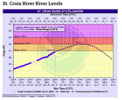
- See the current water levels on the St. Croix River at Stillwater.
- See the current water levels on the Mississippi River at Hastings.
