
On a sunny weekend in June, a virus came to visit our house. While my husband lay quarantined in the guest bedroom, my son, the dog, and I headed north to Wild River State Park to walk in the woods and enjoy the St. Croix River. Charlie spent a couple of hours fishing for buffalo in the shallows, and I hit the trails with Molly the dog, was ambushed by a grouse, and nearly died of fright. For the record, Molly thought that was the best part of the day.

Wild River State Park encompasses 18 miles of St. Croix Riverway and is roughly shaped like a tilted letter “S”. Near the curve of the S, the Sunrise River joins the St. Croix, bringing with it the collected water from 383 square miles of wetlands, lakes, ditches and streams in Anoka, Chisago, Isanti and Washington Counties. Though there are a dozen tributaries that are longer, the Sunrise sends a disproportionate amount of phosphorus downriver to the St. Croix each year. A bi-state report completed in 2012 determined that the Sunrise River needed a 33% reduction in nutrients, equal to 8,303 pounds per year of phosphorus, in order to meet water quality standards, reduce harmful algal blooms, and help restore the St. Croix River to good health (Lake St. Croix Nutrient TMDL).
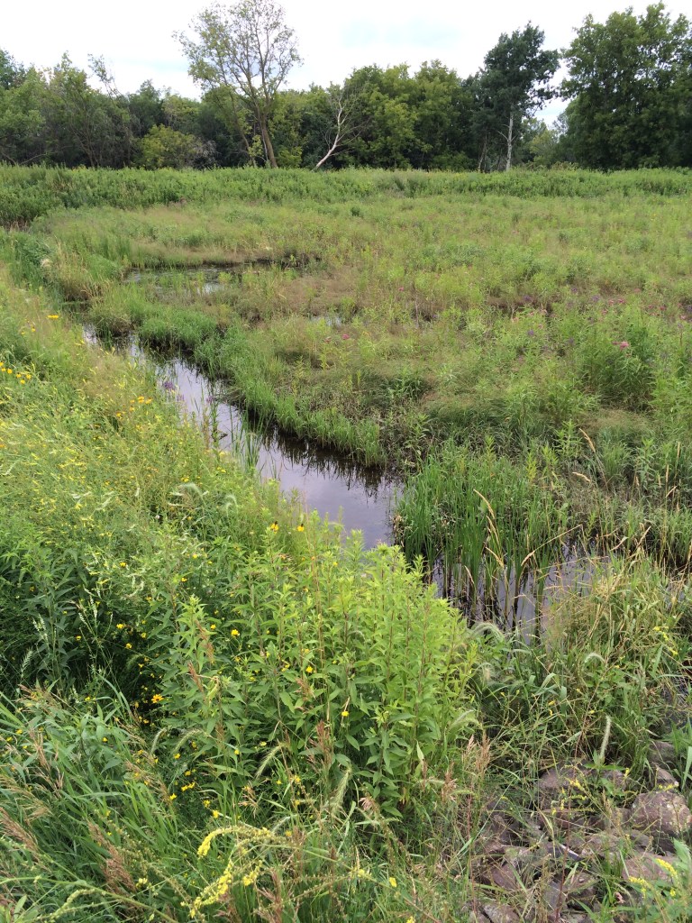
One initiative that is helping to move toward this goal is a wetland enhancement project along Hwy 61 in southern Chisago County that was recently completed by the Comfort Lake – Forest Lake Watershed District (CLFLWD). The project diverts water from an existing drainage ditch system into a restored wetland, where it now flows through multiple pools and is naturally filtered before reaching the Sunrise River. In addition to reducing downstream flooding, the wetland enhancement project will also keep 89 pounds per year of phosphorus and 51,000 pounds per year of sediment out of the Sunrise River.

Water quality problems in the Sunrise River harken back to the early 1900s when farmers ditched and straightened many stretches of the river in order to dry out nearby wetlands to plant crops. Later, when communities such as Forest Lake began to develop during the 1980s and 1990s, watershed districts were not yet in place to help guide development in a way that protects water resources. As a result, stormwater runoff became a major source of pollution for the Sunrise River and downstream water bodies such as Comfort Lake.
“You’re correcting past mistakes with projects like the Sunrise River wetland restoration, but you also need rules to prevent future water quality problems from happening,” says Jackie Anderson, a board manager with CLFLWD who was instrumental in the creation of the watershed district in 1999.

Today, watershed rules in the Twin Cities metro area help to ensure that development and redevelopment projects don’t pollute nearby lakes and streams. CLFLWD also uses diagnostic studies to identify high priority locations for retrofit and restoration projects to help improve water quality.
The recently completed Sunrise River wetland enhancement is located on a 22-acre parcel of tax forfeit land owned by CLFLWD that was originally identified as a priority location for work in 2012. The watershed district has also completed many other initiatives to improve water quality in the Sunrise River and Comfort Lake, including numerous urban stormwater retrofit projects in Forest Lake (75 pounds per year of phosphorus reduced) and a large-scale wetland restoration nearby at Bixby Park (206 pounds per year of phosphorus reduced).
The total cost for the Sunrise River wetland enhancement project was $1.6 million, with $492,000 coming from a Clean Water Fund grant (Minnesota Board of Water and Soil Resources), $300,500 from the Lower St. Croix Watershed Partnership, and $100,000 from a Federal Clean Water Act Section 319 grant (via Minnesota Pollution Control Agency). The Comfort Lake – Forest Lake Watershed District also contributed $727,500 toward the project.
Initial construction of the ponds and diversion channel in the wetland was completed last winter during frozen conditions so that heavy machinery could access the site with minimal impacts. In the spring, the wetland was seeded with a mix of native plant species to enhance habitat for birds and other wildlife. “It will continue to change over time as the vegetation fills in and matures,” says Emily Heinz, CLFLWD planning coordinator.

Though the Sunrise River wetland on Hwy 61 is not accessible for recreation, there are many other locations to walk along or paddle on the Sunrise River, including the Carlos Avery Wildlife Management Area (Chisago County unit has carry-in boat access), Kost Dam County Park, Riverwalk Park in North Branch, and Wild River State Park.

Great initiative by the Comfort Lake – Forest Lake Watershed District! The wetland enhancement project along Hwy 61 is helping to improve water quality in the Sunrise River by reducing phosphorus and sediment. It’s great to see efforts being made to protect our water resources. This article highlights the importance of taking action to preserve and restore our rivers and wetlands. It’s inspiring to see projects like the Sunrise River wetland enhancement that are making a positive impact on water quality. Well done!
LikeLike