
This week, Brown’s Creek Watershed District begins work on a stream restoration project designed to reduce bank erosion and improve habitat for fish along a half-mile stretch of water that flows between McKusick Ave. and the Brown’s Creek State Trail. While the initial tree clearing and earth-moving might appear alarming, the project promises major ecological benefits for the stream and surrounding wetlands.


“Brown’s Creek’s original path had lots of wiggles and meanders,” explains Karen Kill, Watershed District Administrator. “But, historic flooding in the mid-1960s altered the stream’s course and cut off many of those oxbows.”
Hemmed in by the railroad (which is now Brown’s Creek State Trail), and bisected by roads and culverts, Brown’s Creek gradually lost its form. In some locations like in Brown’s Creek Park, the creek became incised and now suffers from continual erosion. In others, such as the reach between Neal Ave and the Brown’s Creek State Trail, it became wide and shallow. As a result, the habitat in that stretch won’t support trout, macroinvertebrates, and native fish.


“When you look at the portion of the stream that flows through Brown’s Creek Park, it is overgrown with buckthorn and box elder trees that form a nearly impenetrable thicket,” Kill says. “This is because the stream is actually draining adjacent wetlands. Removing the buckthorn and boxelder will allow more native plants to thrive and stabilize the soil along the stream so that we have cleaner water and better habitat for pollinators and wildlife.”
After the invasive trees are cleared out, the watershed district will set to work creating a new stream channel that is half as wide and includes numerous twists and turns. These wiggles will create different types of habitat that fish need: deep pools with slow-moving water; shallow riffles with fast, turbulent water running over rocks; and runs with deep, fast water and little or no turbulence. Wood logs will help to anchor the stream bank and the watershed district will seed the entire area with native upland and wetland plants to provide shade and cooling for the water. Next spring, they will also plant native shrubs and trees in a few critical locations.
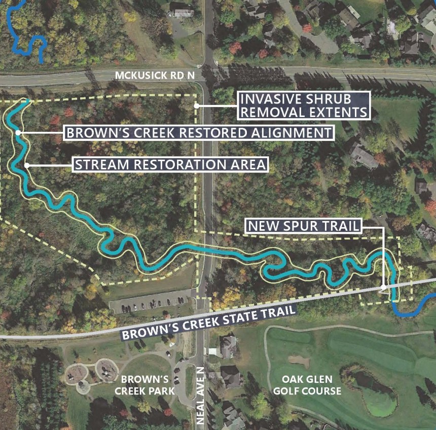
The project will also re-create the natural floodplain that once existed along Brown’s Creek. When it floods in the future, water will be able to flow outside of the stream channel and sediment will settle out along the banks of the creek instead of in the center.
One exciting component of the Brown’s Creek restoration project will be a new ADA accessible trail spur on the east side of Neal Ave. that will enable people to access Brown’s Creek from the State Trail without damaging sensitive habitat along the stream. “We’ve observed several feet of erosion along the creek due to foot traffic,” says Kill, “and we hope that this new trail will get people down to the water with less impact.”
Trail users and local residents can expect to see tree removal and stream restoration work happening along Brown’s Creek throughout the spring and summer, with invasive species management continuing into fall of 2024. The native plantings will happen next spring, in 2025. Brown’s Creek Watershed District is leading the project, with $320,700 in grant support from the Minnesota Pollution Control Agency, via a Federal 319 grant. Minnesota Department of Natural Resources and City of Stillwater are additional partners. Geomorphic Restoration, the project contractor, has completed dozens of similar stream restorations in Minnesota and other states.
“In the short term, this will be a huge visual change,” Kill says. “But we really do expect to see trout in this stretch of Brown’s Creek when we are done.”

