
Owning a lake home is the quintessential Minnesota dream, but it also comes with a lot of responsibility. Shoreline properties usually require more maintenance than other homes, and there are also numerous state and local rules that govern what you can do in and near the water. These rules are designed to protect against water pollution, support wildlife, and promote an enjoyable experience for everyone who lives on or visits the lake.

One of the most important details for any shoreline owner to know is the Ordinary High Water Level (OHW) for your lake. The OHW is set by the Minnesota Department of Natural Resources (DNR) and is expressed as an elevation (in feet) above sea level. To find your lake’s OHW, go to Lake Finder (www.dnr.state.mn.us/lakefind) and look up your lake by name and county. Lake Finder will also provide information about your lake’s size and depth, fish species, and any special fishing regulations or fish consumption advisories.
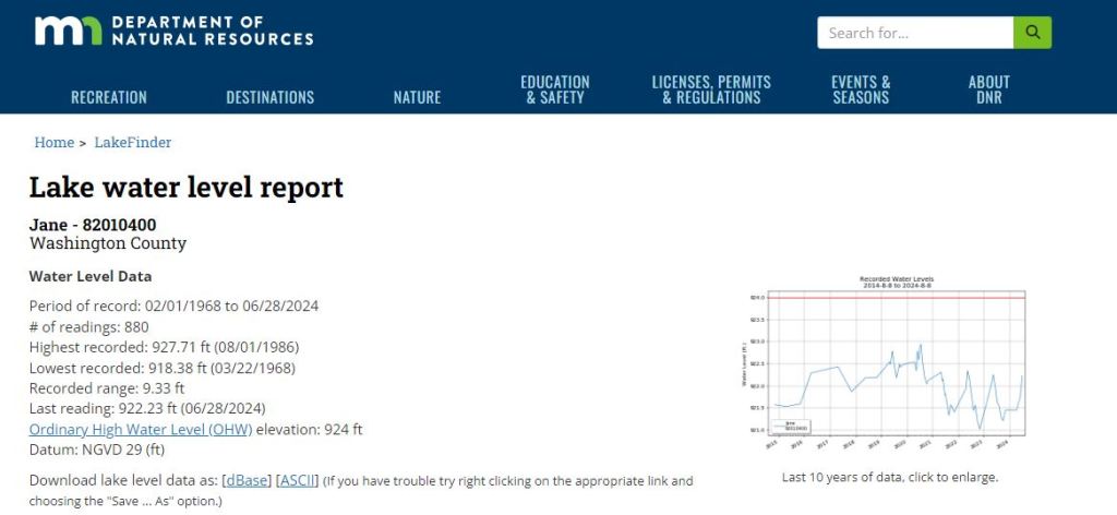
You can think of an OHW as a property boundary. Land above the OHW is your private property; land below the OHW is public property of the State of Minnesota. The Minnesota DNR is basically “in charge” of what happens below the OHW and can require permits (or prohibit) activities such as fishing, removing or treating aquatic plants, excavating, or grading land along the shoreline. Although actual water levels fluctuate from year to year, the OHW for a lake never changes.
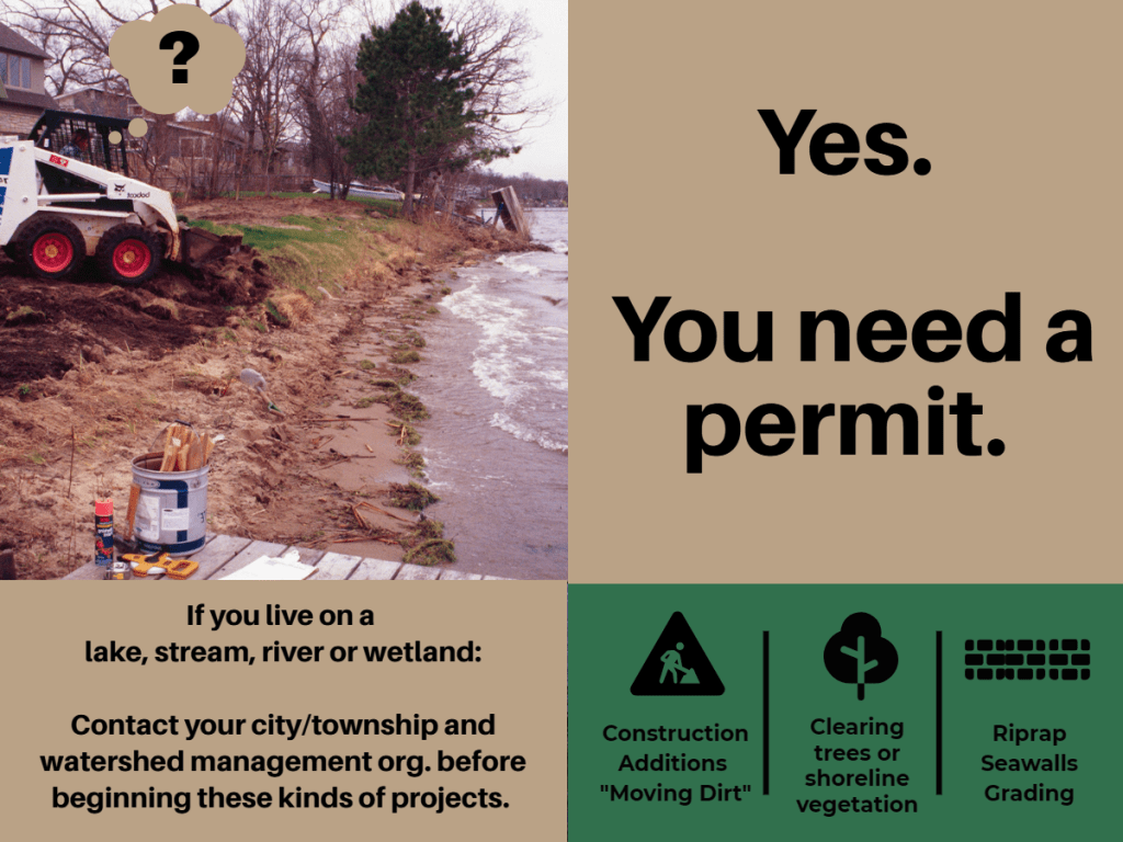
Even though the land above the OHW is your private property, there are still city, township, county, and watershed district rules that govern activities such as building decks and home additions, subdividing land, grading and moving dirt, removing trees and vegetation, and creating driveways and patios. If you’re planning a major home or landscape project, you should always check with both the city/township and watershed district in your area to make sure you understand the rules and get any required permits.
In Washington County, there are eight different watershed management organizations – Brown’s Creek; Carnelian-Marine-St. Croix; Comfort Lake – Forest Lake; Middle St. Croix, Ramsey-Washington Metro; Rice Creek; South Washington; and Valley Branch. You can find a map of the watersheds at www.mnwcd.org/site-visit-signup-form.
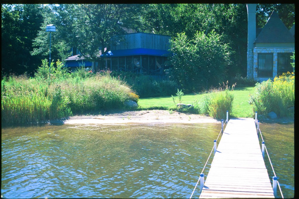
Two of the most common “problem scenarios” for lakeshore owners include creating beaches and installing rock riprap. The Minnesota DNR will sometimes allow landowners to create beaches but only under specific conditions. The sand can’t be more than 6-inches deep, can’t be more than 50ft wide or take up more than half the width of your lot (whichever is less), can’t extend more than 10 feet waterward of the OHW, and can’t be in a posted fish spawning area. In addition, landowners can only add new sand ONCE during the entire life of the property, regardless of how many times the land changes hands. Be sure to check with your local watershed district before you get started, however, because most have stricter rules than the DNR and some prohibit beaches altogether.
Rip rap is only allowed if your shoreline is actively eroding and might be prohibited by your local watershed district. According to Minnesota DNR rules, riprap can’t extend more than 6-feet waterward of the OHW and can’t be steeper than 3:1 (horizontal to vertical). If there is any emergent vegetation along your shoreline (ie. plants like cattails and reeds that grow part in and part out of the water) you will need a permit from the DNR to install riprap. Always check with both the city/township and watershed district in your area to make sure you understand the rules and get any required permits.
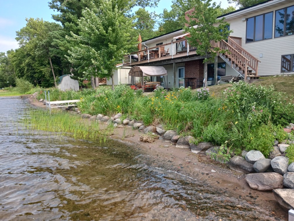
In addition to understanding shoreline rules, one of the most important actions lakeshore owners can take to protect their lakes is to plant and maintain deep-rooted trees, shrubs and native plants along at least half of your shoreline. Maintaining trees and vegetation is an effective and economical way to prevent erosion and will also help to create habitat for spawning fish, nesting loons, frogs, and other wildlife. In addition, natural shorelines dramatically reduce the amount of pollution washed off the land and into the water when it rains.
The Washington Conservation District and watershed organizations in Washington County provide incentive grants, technical assistance, and design support to help property owners plan, install and maintain native shoreline plantings. Learn more and request a free site visit to get started at www.mnwcd.org/site-visit-signup-form. Many other counties in Minnesota offer similar support.

To learn more about living on a lake and find free resources and educational support, check out this collection of resources:
- “East Metro Lakes” e-newsletter for lake associations and shoreline owners, delivered 4-6 times per year (Sign-up here)
- Lower St. Croix Watershed Partnership: www.lsc1w1p.org/shorelines
- This page is a one-stop-shop for info about shorelines and also connects to Minnesota DNR, Blue Thumb, and Minnesota Lake & River Advocates.
- Minnesota DNR
- Resources for landowners:
- Lake Finder – www.dnr.state.mn.us/lakefind
- Restore Your Shore – www.dnr.state.mn.us/rys
- Score Your Shore – www.dnr.state.mn.us/scoreyourshore
- Shoreline alteration info: www.dnr.state.mn.us/publications/waters/shoreline_alteration.html
- Public waters work permits: www.dnr.state.mn.us/waters/watermgmt_section/pwpermits/requirements.html
- Aquatic plant control permits: www.dnr.state.mn.us/shorelandmgmt/apg/permits.html
- Natural shorelines
- Resources for communities:
- Resources for landowners:
- St. Croix Riverway Regulations & Resources: wildriversconservancy.org/protect-restore/lower-riverway
- Landowner’s Guide to the Lower St. Croix Riverway (PDF)
- Zoning application best practices
- Shoreline Realtor On-Demand Training (2.5 CE Hours). This on-line training course for realtors provides information about shoreline rules and programs available to homeowners, including lakeshore development and redevelopment rules, permits required for common building projects, lake & river friendly landscaping, and assistance available to homeowners for shoreline planting projects. Free to members of St. Paul Area Association of Realtors (SPAAR).

thanks!11
LikeLiked by 1 person